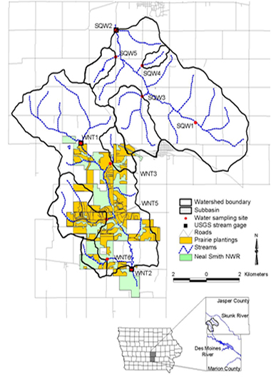
In the Walnut Creek watershed, large tracts of row-cropped land are being reconstructed to native prairie at the Neal Smith National Wildlife Refuge by the U.S. Fish and Wildlife Service. Before restoration began, land cover in both watersheds was about 70% row crop. From 1992 to 2005, nearly 220 acres of prairie was planted each year, so that by 2005, native prairie occupied 23.5% of Walnut Creek watershed. Surface water samples collected in the treatment (Walnut Creek) and control (Squaw Creek) watersheds from 1995 to 2005 documented the effects of prairie restoration on water quality (Schilling et al., 2006). Stream nitrate concentrations were found to have decreased 1.2 mg/L over the 10-year project period at the Walnut Creek outlet, with nitrate concentrations decreasing up to 3.4 mg/L over the same time period in one monitored subbasin with substantial landuse conversion. Interestingly, land use in the control basin of Squaw Creek did not remain static during the same 10-year monitoring period. Row-crop land area increased 9.2% in Squaw Creek as lands previously enrolled in the Conservation Reserve Program as grassland were converted back to row crop production in the late 1990s. Stream nitrate concentrations increased 1.9 mg/L at the Squaw Creek outlet, with annual nitrate in one monitored subbasin increasing nearly 12 mg/L in 10 years where substantial acres were converted to row crops. These results attest to the sensitivity of water quality parameters to changes in watershed management that are, in aggregate, the result of individual landowner decisions.