|
Table 1
Cumulative percentages of total BMP adoption that was cost shared by year (expressed as a percentage of the total amount implemented as given in the bottom line).
|
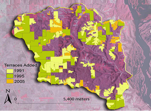
The cumulative adoption of terraces in the watershed is also shown in Figure 6 for 1991, 1995, and 2005. A paired watershed approach was used to assess Sny Magill Creek water quality improvements from 1992 to 2001 (Fields et al., 2005). Analysis of Sny Magill stream flow and water quality data collected during 1991-2001 was performed using a pre/post statistical model. The statistical results indicated that discharge at the watershed outlet increased by 8% over the 10-year period; this could partly be due to routing of runoff water captured by terraces into surface inlet drains (that are often installed just upslope of a terrace) and to the stream. The statistical analysis also showed that the BMPs installed during the 1990s resulted in a 42% decrease in turbidity but only a 7% decrease in total suspended solids (TSS). The TSS results imply that stream bed and bank erosion continued to contribute significant sediment loads to Sny Magill Creek, even after BMP installation reduced sediment delivery from upland areas. The increase in discharge may have further magnified the in-channel sediment contributions. Overall, the TSS results suggest that a long lag time may occur before the full impacts of the installed BMPs are realized. The statistical analysis also revealed that an increase in nitrate concentrations of 15% was found at the SMCW outlet. This indicates greater N leaching, which is consistent with increased infiltration of rainfall that naturally results when conservation practices successfully decrease surface runoff. However, the nitrate concentration level still only slightly exceeded 3 mg/L at the end of the 10-year time period, which is quite low compared with the concentrations measured in most other Iowa stream systems, including the South Fork and Squaw Creek watersheds.