|
Many conservation practices and implementation programs exist to address nonpoint source (NPS) pollution losses from agricultural landscapes (Helmers et al., this issue). In order to select the most appropriate practices and programs for reducing NPS pollution in a specific region while maintaining economic return for the landowner, the interacting processes of agricultural management and watershed hydrology need to be understood across broad spatial scales. On a nationwide basis, it is easy to see how NPS pollution in one part of the country might be different than those in another region of the country. For example, cotton growers in the South, dairy farmers in the Northeast, cattle ranchers in the West, and grain farmers in the Midwest all face unique challenges based on differences in climate, soil types, and cropping patterns. Each region relies on a different set of conservation practices and programs to address NPS pollution. To be effective, conservation systems must be based on an understanding of specific management impacts on water quality problems, and therefore be targeted to reduce, intercept, and/or treat contaminants moving via surface or sub-surface pathways from working agricultural lands.
Within agricultural regions, one might expect greater homogeneity in biophysical features and cropping practices and be tempted to think that one size fits all; i.e., that one set of conservation prescriptions can be used to address the negative impacts of agriculture on aquatic and terrestrial integrity. If this generalization could be made anywhere, certainly a state such as Iowa, dominated by its vast extent of corn and soybean fields, would be suited for a limited set of conservation prescriptions. However, as described in this tale of three watersheds, conservation practices must instead be tailored to individual landowner objectives and local landscape conditions in order to optimize their effectiveness.
The research described in this paper was conducted as part of USDA's Conservation Effects Assessment Project (CEAP) and its Watershed Assessment Studies (Mausbach et al., 2004). The objectives of the project are to evaluate the effects of agricultural conservation practices on water quality, with a focus on understanding how the suite of conservation practices, the timing of these activities, and the spatial distribution of these practices throughout a watershed influence their effectiveness. An additional component of the project is to evaluate social and economic factors influencing implementation and maintenance of practices.
Watershed Descriptions
To evaluate the effects of watershed conservation practices on water quality, and to assess the spatial distribution of these practices, we are focusing on three watersheds in distinct landscape regions of Iowa (Figure 1). By studying three watersheds with differing physical characteristics and possessing a unique set of pollutants, practices and programs, we can better assess the effectiveness of conservation activities and land management decisions.
Landforms
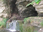
The Sny Magill Creek, Squaw Creek, and the South Fork of the Iowa River (South Fork) watersheds are representative of three distinct landform regions of Iowa (Prior, 1991). In Northeast Iowa, Sny Magill Creek is a third-order stream in Clayton County that drains 35.6 mi2 of the Paleozoic Plateau landform region before discharging directly into the Mississippi River. The landscape of this region is characterized by narrow, gently sloping uplands that break into steep slopes with abundant outcrops of sandstone and limestone. The characteristic limestone bedrock of the area gives rise to karst features (sinkholes, caves, and springs) that are found throughout the Sny Magill Creek watershed (Figure 2). Nearly 80% of annual streamflow is 'baseflow' attributable to ground water discharge from these subsurface sources. This results in "cold water" conditions suitable for highly popular trout fisheries.
The 18.3 mi2 Squaw Creek watershed is located in South-Central Iowa in Jasper County in the Southern Iowa Drift Plain. The landscape of this region is characterized by steeply rolling hills and a well-developed stream network that developed on a landscape composed of geologically old (>500,000 years) glacial till (poorly sorted mixture of gravel, sand, silt, and clay) overlain by geologically recent (17,000 to 31,000 year old) windblown silt (loess). Because of the sloping hillsides and poor infiltration capacity of the soils, rainfall is primarily directed to streams via overland runoff, and only 55% of the stream discharge is attributable to baseflow originating as ground water.
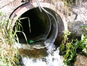
The largest of the study watersheds is the South Fork of the Iowa River, which covers 301 mi2 within Hardin and Hamilton counties in Central Iowa. The landscape is representative of the Des Moines Lobe, the dominant landform region of North-Central Iowa. The terrain is young (about 12,000 years since glacial retreat), and thus much of the landscape is dominated by low relief and poor surface drainage. Prior to settlement by Europeans, the landscape was a complex of wetlands, and the stream network was poorly developed due to the relatively young landscape. The geology of the Des Moines Lobe region consists largely of glacial till deposits in moraines and flat to rolling uplands, clay and peat in depressional "prairie pothole" areas, and sand and gravel deposits in floodplains of rivers and streams. Soil wetness is a major concern for land management and agricultural production. Hydric soils (indicative of soil saturation on at least a seasonal basis) occupy about 54% of the watershed, and artificial tile drainage (Figure 2) was installed in these highly productive and nutrient rich soils to lower the water table and allow crops to be grown. Thus, about 70% of the stream flow in the South Fork watershed originates from subsurface drainage (Green et al., 2006), with most tile discharge occurring during spring and early summer.
Physical features of the three watersheds have a great influence on the timing and magnitude of the routing of water to streams. Watersheds draining older landscapes have greater slope and greater stream density (number of streams per square mile) than younger landscapes (Figure 3). For example, the Sny Magill watershed has twice the average slope as Squaw Creek, which has more than twice the slope of the South Fork watershed. Slopes in Sny Magill are further accentuated because of the bedrock terrain and its proximity to the Mississippi River. The Squaw Creek and Sny Magill watersheds also have nearly three times more streams per square mile than the South Fork. The well-dissected landscape of the Sny Magill watershed shows a greater stream density; thus, rainfall can be quickly routed as overland runoff to sinkholes or streams. In the South Fork watershed, where natural drainage is poor, excess rainfall would collect in potholes or other surface depressions if not for prevalence of subsurface tile drainage, which has accelerated the routing of rainfall water off the land. Watersheds draining the Des Moines Lobe may yield as much water as those draining fractured carbonate bedrock (Schilling and Wolter, 2005).
Relation of Land Use to the Landform Region
Differences in land cover among the three watersheds can be traced largely to their watershed morphologies and the suitability of land for intensive row crop agriculture. Row crops in the Sny Magill watershed, primarily found on narrow upland divides and bottomlands, only comprise 26% of the land area (Figure 3). Grasses and forest are widespread in the Sny Magill watershed, located on steep terrain that is difficult to cultivate. In the Squaw Creek watershed, slopes are not as severe as in the Sny Magill watershed, and row crops are found on 81% of the land area. Grasses are distributed around the watershed on highly erodible land, a practice encouraged by conservation programs. The till plain of the Des Moines Lobe, represented by the South Fork watershed, is also heavily utilized for row crop production, which occupies 85% of the watershed area.
Animal Agriculture
In the early 1900s, most small farms in Iowa had livestock, often including cattle, swine, and chickens. As a result of changes in farm policy and economies of scale, all three watersheds have experienced shifts in animal agriculture that are representative of changes across the larger landform regions (Figure 1). Historically, the Sny Magill watershed had significant numbers of dairy cattle utilizing available grasslands for forage. While still a significant industry, dairy cattle within Sny Magill have decreased greatly, with a resulting shift in some grassland acreage to row crop agriculture (soybean acreage especially increased in Iowa as pasture and hayland decreased). Livestock is comparatively absent in the Squaw Creek watershed except for several cow-calf operations. Nowhere is the concentration of livestock more apparent than in the South Fork watershed, where most swine and chickens are raised in confined animal feeding operations (CAFOs). There are nearly 100 CAFOs (mostly swine) in the watershed. Based on inventories reported for permitted facilities, hogs and chickens in the South Fork watershed number 1,654 and 2,880 per square mile, respectively, which are densities considerably greater than the other two watersheds combined (Figure 3). All the reported chickens are housed in one large egg-producing facility, while swine facilities are abundant across the central part of the watershed. We estimate that about a quarter of the watershed receives manure applications annually, assuming this is applied prior to corn at a rate equivalent to that crop's uptake of nitrogen (about 190 lb N/ac). Usually these applications are done by injection, and carried out in the fall when soils tend to be dry and most easily trafficked by manure tankers and applicators.
NPS Pollutants and the Landscape
Because of their different watershed characteristics, land use, and livestock histories, non-point pollutant sources and transport vary greatly among the three watersheds (Figure 3). Pollutants of particular concern in Iowa are sediment, nutrients (nitrate and phosphorus), and fecal bacteria (E. coli). In Iowa, nitrate concentrations in streams relate to the amount of row crops in a watershed (Schilling & Libra, 2000), and nitrate-N concentrations are highest in the South Fork and Squaw Creek watersheds, with median concentrations of 14.2 and 9.5 mg/L, respectively. Tile drains contribute greatly to nitrate losses in the South Fork watershed. In the mid-1990s, the USGS found stream nitrate concentrations in the South Fork watershed to be among the highest observed in the United States (Becher et al., 2001).
In contrast, nitrate concentrations are considerably lower in the Sny Magill watershed, averaging 3.3 mg/L over 10 years, a value that would be the envy of most other regions of Iowa. The smaller concentration results from the differences in land use (Figure 3). Fecal bacteria counts are also highest in the South Fork watershed; however, multiple sources of bacteria are suspected because patterns do not always follow the distribution of livestock. Yet, research suggests that these bacterial losses in runoff are greatest when that runoff occurs within several weeks of manure application. Fecal bacteria concentrations in Squaw Creek are also elevated, which may be surprising, given the lower livestock densities. However, cattle with direct access to the streams, wildlife, and inadequate septic systems may all contribute to fecal contamination of Iowa streams.
Sediment loss is also a major concern in these watersheds (Figures (3 and 4). The greatest annual sediment loss per unit area was associated with the Squaw Creek watershed (0.69 tons/ac per year), whereas mean annual sediment loss from Sny Magill and South Fork watersheds averaged 0.26 and 0.28 tons/ac, respectively. Considering that row crops cover only 26%of the land area in the Sny Magill watershed, actual soil loss per acre of cropland may be substantially greater. Long-term sediment monitoring data in the Sny Magill and Squaw Creek watersheds indicates that sediment transport is very flashy in both watersheds, with much of the annual sediment loss transported by runoff from a few intense rainfall events. In Squaw Creek, on average, about 40% of the watershed's annual sediment loss occurs on the single day of greatest runoff.
Sediment losses from watersheds result from overland flow across the landscape, causing sheet, rill, and gully erosion, as well as substantial contributions from streambanks. In the South Fork watershed, sediment losses are actually about three times higher than typically measured in the Des Moines Lobe region. In the lower third of the watershed, lands become more highly erodible in an area of hilly moraines near the Des Moines Lobe's edge, and the river erodes its banks as it meanders across an alluvial valley (Figure 4). In some Iowa watersheds, streambank erosion can contribute more than half of the annual sediment load exported from a watershed.
Phosphorus is strongly adsorbed to sediment, which was reflected in Squaw Creek having both the greatest average sediment yields and greatest median concentrations of total P (0.14 mg/L) among the three watersheds. Squaw Creek's median P concentration is more than twice what EPA has proposed as the standard for Midwest streams. Concentrations of P in the South Fork, by comparison, had a median of 0.07 mg/L during three years of weekly-biweekly sampling. Recent groundwater sampling from 24 wells located throughout the South Fork watershed has shown median and maximum total P concentrations of 0.030 and 0.340 mg/L, respectively. These groundwater P concentrations are found in similar materials and landscapes in Iowa (Burkart et al., 2004), and suggest that groundwater can also be a P contributor to streams.
Tailoring Conservation Practices to Watersheds and NPS Pollutants
Conservation practices used on row crop fields in the three watersheds reflect respective watershed characteristics and land use histories. A field-by-field assessment of conservation practices was conducted in each watershed to assess the variety and distribution of practices. An analysis of tillage practices, terraces, and contour farming shows the degree to which land managers have used these conservation practices to reduce nutrient and sediment losses from the three watersheds. Of the three tillage practices assessed (conventional tillage, mulch till, and no till), mulch till was most widely utilized in all watersheds. Mulch tillage (>30% residue cover) was used on 62 to 91% of all row crop fields, whereas no till was used on 8 to 16% of the fields. Conventional tillage (<30% residue cover) was rarely used in Sny Magill and Squaw Creek, but was used on 30% of cropland in South Fork. Erosion losses from crop fields in South Fork are not a major concern in the flat, till plain portion of the watershed. In areas of the Northern United States, with relatively flat terrain and poorly drained soils, many producers still view conventional tillage as the most viable practice because the exposed soil is warmed faster in spring, often allowing earlier seeding and emergence of the crop.
In the Sny Magill watershed, contour farming, terraces, and other engineered structures are prevalent practices for reducing sediment losses from the steeper slopes in that watershed. Although row crop fields occupied only 26% of the land area in Sny Magill, most are terraced (77%) and/or farmed using contour planting (92%). Other engineered conservation practices are also used extensively throughout the Sny Magill watershed, including a total of over 150 sediment basins and grade stabilization structures. Terraces are not as common in Squaw Creek (23%), but half the farm fields are planted on contours. Terraces and contour farming are not common in the South Fork watershed; fields with terraces occupy less than 10% of the watershed's cropland.
A Tale of Three Watersheds - revisited
In this tale of three Iowa watersheds, significant differences in NPS pollutants and practices emerged in a state considered by many to be uniformly agricultural. Much of the differences can be attributable to their unique landform history that has been exploited uniquely for intensive row crop and livestock development. In the South Fork watershed, extensive wetlands on recently glaciated till plains were drained by settlers, and agricultural development then intensified during the past century. The land is well suited for crop and livestock production, but subsurface tile drainage increases losses of nitrate, and the rapid routing of tile discharge, combined with surface runoff, may enhance movement of bacteria, P, and sediment. In Squaw Creek, with steeper slopes in row crops, conservation practices such as reduced tillage and contour farming methods are more prevalent. However, losses of nutrients, sediment, and fecal bacteria remain as major concerns in the watershed, possibly because hydrologically sensitive areas are used for row crops or grazing. Row crop acreage in the Sny Magill watershed constitute only about 25% of the land area and most row crop fields have conservation tillage or structural practices such as terraces. However, the steep slopes and karst drainage in the watershed make Sny Magill watershed perhaps the most vulnerable among the three streams evaluated.
Apparent in this tale of three Iowa watersheds is that, in order to provide the greatest return on the public's investment in conservation, it is imperative that practices be tailored to the most local of landscape conditions and landowner objectives. Targeting is needed to place specific conservation practices on the land to either reduce pollutant concentrations or attenuate their transport. No single practice can be viewed as the answer in all cases, and a one-size-fits-all approach is likely doomed to failure, or at least doomed to provide little return on the public investment. Recent advances in assessment technologies and record keeping are only now beginning to allow us to understand the distribution of practices on the land and their impacts on water quality. Significant challenges remain to develop better assessment, monitoring, and modeling techniques to capture the inherent differences among our watersheds in order to design conservation practices and programs providing greater water quality benefits for lower cost. The challenges are not only in assessing resource needs against the mosaic of land use and terrain that occur within watersheds, but also to then develop better policy and planning tools that can help achieve watershed-scale conservation goals through implementation at the individual farm scale.
For More Information
Becher, K.D., Kalkhoff, S.J., Schnoebelen, D.J., Barnes, K.K., & Miller, V.E. (2001). Water-Quality Assessment of the Eastern Iowa Basins - Nitrogen, Phosphorus, Suspended Sediment, and Organic Carbon in Surface Water, 1996-98. U.S. Geological Survey Water-Resources Investigations Report 01-4175. Iowa City, IA.
Burkart, M.R., Simpkins, W.W., Morrow, A.J., & Gannon, J.M. (2004). Occurrence of total dissolved phosphorus in surficial aquifers and aquitards in Iowa. Journal of the American Water Resources Association, 40(3), 827-834.
Fields, C.L., Liu, H., Langel, R.J., Seigley, L.S., Wilton, T.F., Nalley, G.M., Schueller, M.D., Birmingham, M.W., Wunder, G., Polton, V., Sterner, V., Tial, J., & Palas, E. (2005). Sny Magill Nonpoint Source Pollution Monitoring Project: Final Report, Iowa Department of Natural Resources, Geological Survey Bureau Technical Information Series 48, Iowa City, IA.
Green, C.H., Tomer, M.D., DiLuzio, M., & Arnold, J.G. (2006). Hydrologic evaluation of the Soil and Water Assessment Tool for a large tile-drained watershed in Iowa. Transactions American Society of Agricultural and Biological Engineers, 49(2), 413-422.
Helmers, M.J., Isenhart, T.M., Kling, C.L., Mooreman, T.B., Simpkins, W.W., & Tomer, M. (2007). Agriculture and water quality in the Cornbelt: Overview of issues and approaches. Choices 22(2), this issue.
Mausbach, M.J., & Dedrick, A.R. (2004). The length we go: Measuring environmental benefits of conservation practices. Journal of Soil and Water Conservation, 59(5), 96A-103A.
Prior, J.C. (1991). Landforms of Iowa. Iowa City, IA: University of Iowa Press, 153 pp.
Schilling, K.E., Hubbard, T., Luzier, J., & Spooner, J. (2006). Walnut Creek watershed restoration and water quality monitoring project: final report. Iowa Department of Natural Resources, Geological Survey Bureau Technical Information Series 49, Iowa City, IA. Available online: http://www.igsb.uiowa.edu/.
Schilling, K.E., & Libra, R.D. (2000). The relationship of nitrate concentrations in streams to row crop land use in Iowa. Journal of Environmental Quality, 29(6), 1846-1851.
Schilling, K.E., & Wolter, C.F. (2005). Estimation of streamflow, baseflow and nitrate-nitrogen loads in Iowa using multiple linear regression models. Journal of American Water Resources Association, 41(6), 1333-1346.
|
|
Other articles in this theme:
- Agriculture and Water Quality in the Cornbelt: Overview of Issues and Approaches
Matthew J. Helmers, Thomas M. Isenhart, Catherine L. Kling (Guest Editor), Thomas B. Moorman, William W. Simpkins, and Mark Tomer
- Privatizing Ecosystem Services: Water Quality Effects from a Carbon Market
Silvia Secchi, Manoj Jha, Lyubov Kurkalova, Hongli Feng, Philip Gassman, and Catherine Kling
- Nitrate Reduction Approaches
Christopher Burkart and Manoj K. Jha
|
|