|
Agriculture will be influenced by future climate changes. In order to see these influences and examine their implications one must obtain a climate change projection. Climate change projections can be obtained from Global Climate Models (GCMs) run under scenarios that are forced by the drivers of the climate system. This paper will give a very brief summary of the GCMs and scenarios then present projections for the next half-century.
Climate Models and Their Reliability
The construction of global climate models (GCMs) began in the mid-seventies in parallel with the invention and proliferation of high-speed computers as well as the deployment of global observing systems such as satellite and measurements made directly in the atmosphere or ocean. The GCM is a physically-based numerical simulation model that includes the conservation of mass and water as well as momentum and energy. The dynamics of the oceans are coupled into the process. These models have descended from the numerical weather forecast models that date back to the 1950s.
Changes in climate are described statistically. For present purposes we are interested in the statistics of such quantities as temperatures and precipitation over large regions. The most important descriptive statistics include mean values averaged over say a decade and fluctuation indicators such as the variance and some extreme values. Some other specialized statistics include the frequency and intensity of hurricanes, El Nino events, etc.
Climate models strive to produce these statistics over historical periods when being validated and in the future under alternative scenarios for projections. The scenarios represent factors or "forcings" that affect climate. The most important climate forcing is the temporal evolution of the so-called greenhouse gases (GHGs) such as carbon dioxide, methane, nitrous oxide and many others. Concentrations of these GHGs have been observed directly for half a century, and measurements can be taken back 650,000 years by measuring the amount trapped in air bubbles in polar ice. Other important forcings include dust left high in the atmosphere and lasting a few years following some volcanic eruptions, changing sun brightness and aerosols (tiny particles floating in the air, some manmade).
Once a forcing scenario (e.g., steadily increasing carbon dioxide) is prescribed in the model simulation, feedbacks come into play to amplify or diminish the climate response. Globally the largest feedback is due to the response of water vapor to surface warming. When the surface warms, more water vapor evaporates and works its way high in the atmosphere and this forces even more climate change. The water vapor feedback roughly doubles the response to the forcings mentioned above. Other feedbacks include
- Ice/snow cover (albedo) effect, which makes the planet less reflective as it warms, thereby enhancing the warming.
- Clouds, which might amplify or diminish climate effects and pose possibly the largest uncertainties in current GCMs.
About 20 GCM modeling groups around the world simulate the climate response to various forcing scenarios for the reports produced every five years by the Intergovernmental Panel on Climate Change (IPCC). The GCMs unanimously agree that increases in GHG emissions have led to a steady increase in global temperatures. Comparing projections suggests that if carbon dioxide were doubled global level temperatures would increase by about 3 deg C (5.4 deg F) with a range across the models of about plus/minus 50%. At current rates of carbon dioxide emission increase (0.5% per year), the doubling will occur in 140 years. When other greenhouse gases are included the effective doubling occurs in about 70 years.
Across the GCM projections several important robust and relevant features emerge:
- Global average temperatures increase with land areas leading ocean areas.
- There is more warming toward the poles and less in the tropical areas.
- Sea Level will increase by some 0.30 to 0.50 meters if there is no appreciable melting of the ice sheets on Greenland or the West Antarctic Peninsula.
- Globally precipitation increases, but less than would be suggested by the rate of increase in atmospheric water content (relative humidity stays close to constant).
- Most of the increases in precipitation are in the middle latitudes such as the northern tier of the contiguous United States, especially the Northeast. In the Continental United States expect more precipitation north of the Gulf of Mexico, less to the west of it.
- Regions where the climate is considered �tropical� will expand polewards with accompanying changes precipitation patterns (more on this later).
- Mountain snow packs will shrink and last a shorter time into the spring leading to changes in river flows. Snow cover on grazing lands will begin later and melt earlier than at present.
How much faith should we put in these projections? Most outspoken criticisms of the model simulations seem to be based on other than scientific arguments. In the end we are forced to rely on expert assessments. In such a context the U.S. National Academy of Sciences has published many assessment reports in which the mainstream assertions in the last paragraph are endorsed. The most publicized and recent expert assessment comes from the 2007 IPCC�s Fourth Assessment Report, abbreviated as the AR-4. The climate science component of AR-4 (Working Group I), made use of the 20 or so GCMs in assembling projections.
Climate Forcing Scenarios
In the AR-4 Working Group II Report Chapter 2, the IPCC discusses future scenarios. All scenarios reflect future population projections. Some scenarios consider paths that emphasize centralized planning and cooperation, while others take the way of regional differentiation. A variety of such scenarios are then used to generate future trends for greenhouse gas emissions and other human-originated forcings. These are then used in GCM simulations for the Twenty First Century. One important result is that through the year 2030 the simulated results are insensitive to which scenario is employed; but after that the results for different scenarios begin to diverge. Mean warming for the globe by 2090-2099 relative to 1980-1999 is projected to be 1.8, 2.8, and 3.4�C for three representative scenarios (B1, A1B, and A2).
- The B1 scenario is characterized by population leveling at 2050, a world economy that is service and information based, with clean technology.
- A1B contains a market oriented, rapidly growing economy with the same population path as B1 while technology employs well balanced sources of energy.
- A2 includes a population continuously increasing along with an economy that is regionally oriented and lowest in per capita growth with a technology that evolves the slowest with the most fragmented development.
Across these scenarios A2 is the most pessimistic and B1 the most optimistic in terms of heating due to greenhouse gas emissions. Since these three scenarios are fairly representative of the spread of global outcomes at the end of the century, we adopt them as our choices for investigating the regional rates of change over the next century.
Future Climate Projections for the Continental US
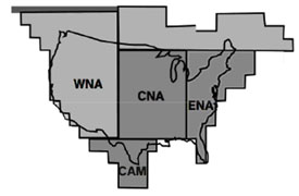
Following AR-4, Working Group II we divide the Contiguous US into regions as shown in Figure 1.
The trends in temperature and precipitation and precipitation for different seasons are shown in the table (taken from figures in AR-4, Working Group II, Chapter 2:)
Recent research (Seager et al., 2007) completed too late to be included in the AR-4 suggests that the U.S. Southwest using the same AR-4 models will be particularly dryer perhaps to the extent that normal precipitation minus evaporation might compare with the record droughts of the 1930s and 1950s.
Summary
We can summarize the results most relevant to U.S. agriculturalists via the following statements. It is very likely that the Continental United States will be 30C (5.40F) warmer plus or minus 1.50C (2.70F). There are likely to be more heat waves with more mid-latitude drying in summer and an increased risk of prolonged droughts (and their consequences, fires, etc.). Precipitation in the United States will be mixed: a) the Eastern Sector will likely have more rain than now because mid-latitude storm tracks are likely to edge northwards. b) The Southwest is likely to be much drier as the storm tracks move northwards and the tropical summers experienced in that region are likely to be longer. Most models suggest that the multi-year swings of wet and dry periods will be more pronounced than those of today�s climate. Sea level will rise a foot or two under the conservative assumptions that melting of the big ice sheets on Greenland and Antarctica does not accelerate catastrophically.
For More Information
Richard Seager, Mingfang Ting, Isaac Held, Yochanan Kushnir, Jian Lu, Gabriel Vecchi, Huei-Ping Huang, Nili Harnik, Ants Leetmaa, Ngar-Cheung Lau, Cuihua Li, Jennifer Velez, Naomi Naik, (2007): Model Projections of an Imminent Transition to a More Arid Climate in Southwestern North America. Science. 25 May 2007 316: 1181-1184. [DOI: 10.1126/science.1139601]
Carter, T.R., R.N. Jones, X. Lu, S. Bhadwal, C. Conde, L.O. Mearns, B.C. O�Neill, M.D.A. Rounsevell and M.B. Zurek, 2007: New Assessment Methods and the Characterisation of Future Conditions. Climate Change 2007: Impacts, Adaptation and Vulnerability. Contribution of Working Group II to the Fourth Assessment Report of the Intergovernmental Panel.
|