In 1981, the inter-agency National Agricultural Lands Study (USDA and CEQ, 1981) triggered a vigorous debate about the disappearance of American farmland. Although the dire predictions of the 1981 study—it projected a need for 77 million additional agricultural acres by the year 2000—did not come true, a recent article by Francis et al. (2012), shows that the more alarmist view about farmland that was common in the 1970s and 1980s is alive and well.
Francis and his co-authors argue that we face farmland challenges today that we did not have to deal with 40 years ago. Although they ignore some reasons for optimism, such as increases in yields from genetically-modified seeds, there is little doubt that most 21st century trends affecting the long-run availability of farmland are troubling ones. A list of such trends would include global demand side pressures—international development and greater consumption of land-intensive meat products and the perpetual concern over global population growth—and global supply side pressures--environmental degradation, climate change, alternative use of land for biofuels, and diminishing returns from traditional cross-breeding technologies. Regarding urbanization, the threats of sprawl continue and its potential to pave over especially productive farmland that is located near sites of original colonial settlement with favored floodplains and well-watered, flat soils near water transportation. The local food movement has brought new opportunities for farming that are close to, and in some cases entirely within, urbanized areas. This social trend was not foreseen at the time of the 1981 Agricultural Lands Study. It offers some hope for the preservation of high-quality agricultural land, provided that: (1) it allows farmers to outbid developers for at least some urban parcels that would otherwise have been developed or (2) it adds previously developed land, such as distressed properties in central cities, to the agricultural land base and proves that farming can take place efficiently there.
State and local farmland preservation programs, as well as the federal Farm and Ranch Lands Protection Program of 1996, were designed largely to protect farmland resources from urban encroachment, following the call to action of the 1981 agricultural lands study. What has been learned about the relationship between urban expansion and long-run farmland availability in the United States? Has the threat posed by development changed over the last thirty years? The short answer is that the threat to America’s agricultural land base from development remains long-term and speculative rather than urgent. Where domestic food supply is concerned, issues like water supply and soil erosion are more pressing. Agricultural markets continue to be characterized by long distance shipping, while the price and use of suburban parcels is determined today by local factors, especially the demand for urban uses.
None of this is to say that state and federal policy makers should not plan for extreme contingencies, like those related to climate change or a sharp increase in transportation costs. State and local policy makers, meanwhile, will continue to respond to local voter demands for open space, sprawl control, and maintenance of a land reserve for local agriculture.
| Percentage decline in land area (10-year average 1982-2010) | ||||
| Percentage of usable open land that is prime farmland | Prime farmland | Rural open land | Non-forested open land | |
| Continental United States | 23.3% | -1.6% | -1.3% | -1.8% |
| Mid-Atlantic region | ||||
| New Jersey | 22.5% | -10.8% | -8.0% | -13.7% |
| Pennsylvania | 14.8% | -4.5% | -2.4% | -6.7% |
| Great Lakes region | ||||
| Ohio | 52.8% | -2.4% | -2.1% | -3.0% |
| Michigan | 26.1% | -2.2% | -1.8% | -4.0% |
| Southeast region | ||||
| Alabama | 22.4% | -3.0% | -1.8% | -6.3% |
| Georgia | 23.7% | -2.6% | -2.9% | -9.2% |
| Plains region | ||||
| Iowa | 55.1% | -0.4% | -0.4% | -0.4% |
| South Dakota | 14.6% | -0.7% | -0.2% | -0.2% |
| Southwest region | ||||
| Arizona | 1.6% | -14.2% | -0.8% | -0.5% |
| New Mexico | 0.3% | -11.5% | -0.2% | -0.3% |
| Mountain region | ||||
| Idaho | 16.8% | -3.1% | -0.8% | -1.0% |
| Pacific region | ||||
| California | 12.2% | -4.7% | -2.5% | -3.0% |
The most commonly used definition of high quality agricultural land in the United States is the prime farmland category of the U.S. Department of Agriculture’s Natural Resources Conservation Service (NRCS). Prime farmland is defined by the NRCS as land that “has the combination of soil properties, growing season, and moisture supply needed to produce sustained high yields of crops in an economic manner if it is treated and managed according to acceptable farming methods” (USDA, 2014). By this definition, 23% of the non-federal open land in the continental United States qualified as prime farmland in 2010, whether or not it was used to grow crops (USDA and ISU, 2013).
Although the prime farmland designation is widely used to measure land that deserves the highest-priority protection, it should be remembered that land classifications are not immutable—poorer land can become “prime” when irrigated— and there is considerable local and regional variation within the prime category.
Vining, Plaut, and Bieri (1977) confirmed that prime farmland was disproportionately located in or near the nation’s largest metropolitan areas, although they described the relationship as “modest.” These authors observed large differences, however, in the co-location of prime farmland and urban settlement across U.S. census regions. This means that the loss of prime farmland to urbanization could be far worse in New Jersey than, say, Georgia—even if population growth rates were the same. Of course, state population growth rates are not the same. This fact must also be taken into account when analyzing—or forecasting—the loss of prime farmland in different parts of the country.
The 2010 NRI allows a fairly precise estimate of the rate of loss of various types of land due to urbanization, because it reports the amount of each undeveloped land type remaining in each survey year. The data on remaining rural acres are available for each of the lower 48 states for seven years between 1982 and 2010. The first row of Table 1 reports data for the entire United States. Because local conditions vary widely, the remaining rows report data on a set of representative states from different census regions throughout the United States.
The first column of Table 1 shows the percentage of undeveloped, nonfederal land in each state that was characterized as NRCS prime farmland in 2010. The second column shows the percentage decline in prime farmland in each state between 1982 and 2010. The third column shows the percentage decline in available rural acres of all types, including forested, that could be used to raise food or livestock if needed.
A Prime Farmland Risk Profile for the 48 Contiguous States
There are different ways to characterize the risk to farmland from urbanization across states, and therefore where to prioritize preservation efforts. For example, we might ask the question: Which states have a high percentage of farmland that is designated prime? Other things equal, these are places where a state-level preservation effort would have the greatest impact on prime farmland, viewed nationally. Figure 1 shows that these states cluster in those parts of the country with sufficient rainfall, drained by large river systems, and with land that is relatively flat.
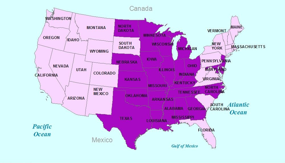
Source: USDA, National Resources Inventory, 2013.
But Figure 1 ignores the threat to this prime farmland that is generated by urban growth. Figure 2, therefore, shows housing growth over the same period for which farmland decline is measured in the 2013 NRCS report. This map shows the well-known sunbelt/west coast growth phenomenon of the last several decades. It is silent, however, on whether growth in a given state is eliminating prime farmland at a faster rate than other kinds of rural land.
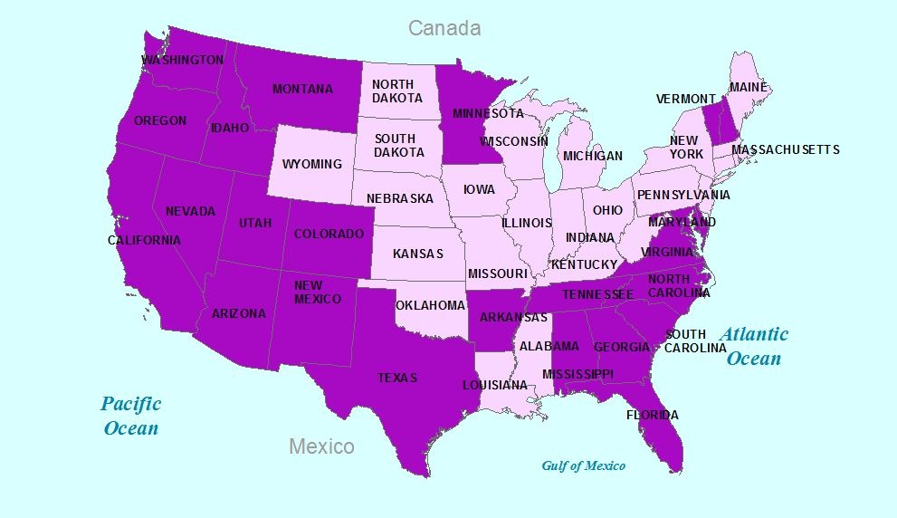
Source: U.S. Bureau of the Census, Decennial Census of Housing, 1980 and 2010.
Figure 3 addresses this third question—while ignoring the first two. It shows states that rank above the median on the ratio of prime farmland decline to decline of all rural land. These are states where prime farmland is disproportionately in the path of development, viewed independently of the speed of that development.
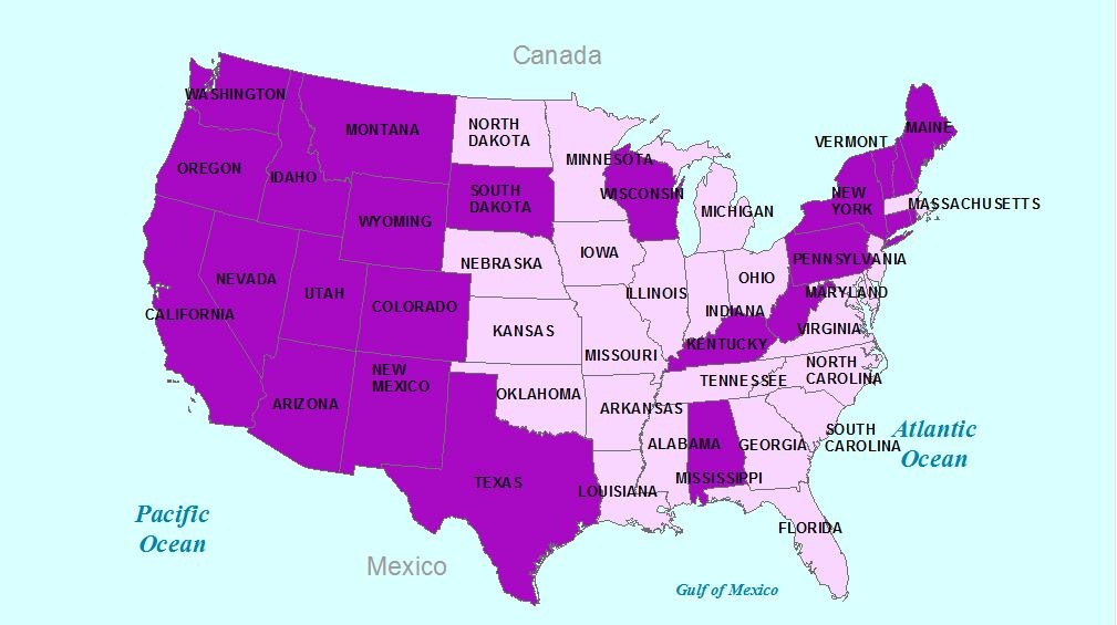
Source: USDA, National Resources Inventory, 2013.
In the west, Figure 3 looks similar to Figure 2. Not only has the West been growing rapidly, it is also understandable that western cities were founded close to this region’s very limited stocks of prime farmland.
Comparing the Northeast and Southeast regions in Figures 2 and 3, however, leads to the conclusion that states losing prime farmland more rapidly than other rural lands—generally in the Northeast—are not the states that have grown most rapidly, which are generally in the Southeast. States with a disproportionate quantity of prime farmland do not align neatly along north-south lines which can be seen in Figure 1. Having said that, it is clear that northeastern states with slower long-term growth rates but greater relative risk to prime farmland have been more actively preserving land than their southern counterparts (AFT, 2005).
Are there any states that rank high on all three farmland preservation risk factors? Yes, there are two: Texas and Alabama. Neither of these states made AFT’s 2005 roster of states authorizing and using state funds for preservation (AFT, 2005). A likely explanation is the South’s small-government political culture. Private foundations may be picking up some of the slack by purchasing conservation easements in these two states.
Northeast states have seen much of their farmland revert to forest over the last century; there is no reason why we could not reclaim some of this land for food production if necessary. Having said that, it must also be acknowledged that a significant portion of today’s forests are on steep slopes or are regarded as necessary for wildlife preservation, carbon sequestration, or other environmental services. For this reason, Table 1’s final column shows the percentage decline due to urbanization of all non-forested, open rural land that existed in 1982. Together, the three right-hand columns in Table 1 span a range of subjective definitions of open land that should be used, or considered a reserve, for agricultural production in the United States.
The first thing to notice in Table 1 is that prime farmland has been declining more rapidly than all rural land in every state except for Iowa and Georgia. This result supports the view that U.S. cities were mostly founded on prime farmland, and are therefore expanding disproportionately onto this valuable resource.
The two exceptions to this rule are instructive. In the case of Iowa, a significant percentage of the land in both rural and metropolitan settings is designated prime, and population growth has been modest. In the case of Georgia, note that Atlanta, the state’s dominant growth engine, is one of the first U.S. cities to be founded on the basis of access to railroads rather than rivers. It follows that in Georgia, the soils sitting in the path of urban development are no better suited to agriculture than those in more remote areas.
Some studies have used historical trends like those reported in Table 1 to create straight-line forecasts of such things as future agricultural acres per resident (Francis et al., 2012), or years until complete build-out in a single state (Hasse and Lathrop, 2008). As authors Haase and Lathrop admit, straight-line projections of farmland loss are misleading. They assume, for example, that the price of an increasingly scarce resource does not rise, which would cause its rate of depletion to slow. Similarly, while the total stock of land with agricultural potential is necessarily reduced by development, economic incentives cause “forest, pasture, range, and other rural land [to be] converted to cropland,” thus reducing the net effect on food supply (Heimlich and Krupa, 1994). The existence of market forces means that straight-line forecasts are unlikely to come true; still, they can provide an intuitive sense of the urgency of farmland loss in different locations.
For the continental United States, a straight-line projection technique suggests that prime agricultural land would be completely eliminated in the year 2572, all rural land would be gone in 2713, and non-forested rural land would disappear in 2498. State-level exhaustion years range from as early as 2051 for Arizona’s small quantity of prime farmland—a situation that could potentially be improved if enough water could be found—to dates beyond the year 4000 for various definitions of rural land in Iowa, New Mexico, and South Dakota.
Other build-out scenarios worth mentioning include California, which would pave over its significant stock of prime farmland by 2180; and Georgia, which would run out of open land before the end of the current century—but only if its extensive forests were regarded as off limits for growing crops.
On the whole, Table 1 supports the findings of the many 1980s studies arguing that the sky is not falling due to urban sprawl—a conclusion that is even more emphatic when you consider what would happen to the price of agricultural land as it became increasingly scarce. The table does, however, raise interesting issues related to local food supply versus shipment from afar.
For example, by virtue of their enormous stocks of prime farmland, states like Ohio and Iowa are logical alternative sources of food for an increasingly urbanized Northeast. This particular safety net, however, appears to have some holes in it. A quick look at maps published in the 2013 NRI report shows that Iowa is the continent’s epicenter for “sheet and rill erosion” producing sediments that flow down the Mississippi River. This fact should remind us that prime U.S. farmland can disappear for reasons other than urbanization. In Iowa, continued availability of topsoil is the chief threat; in Florida, inundation from rising sea levels might be considered, alongside urbanization. In California, farms in the state’s famed central valley could run out of groundwater for irrigation long before they are covered by homes. It follows that urbanization is far from the only thing to consider when thinking about the long-term availability of this critical natural resource (Francis et al., 2012).
A fact sheet published by American Farmland Trust (AFT) states that 86% of the nation's fruit and vegetables and 63% of its dairy products are produced in areas “under the threat of development” (AFT, 2014b). The clear implication of this statement is that these commodities can only be grown on those prime agricultural soils that are scheduled for early elimination as a result of urbanization (Francis et al., 2012).
Even considering the slightly greater amount of prime farmland that is near population centers, it is incorrect to assume that fruits and vegetables can only be grown in urban fringe locations. The majority of prime farmland, as is true for all land, remains nonmetropolitan. Regions specializing in fruits and vegetables were established at a time when the transportation of heavy agricultural products was difficult. This led to patterns of proximity to urban areas that persisted even after transportation costs fell—consider, for example, New Jersey, the “Garden State”. Although relatively few fruits and vegetables sold in America’s supermarkets today are local, such high-value crops could potentially be grown on the fringe of any metropolitan area even as this fringe moves outward.
An important reason for this is that prime farmland is not strictly required to grow fruits and vegetables. In fact, as noted by a reviewer of this article, high-value fruit and vegetable crops often require soil characteristics that preclude a soil from the prime designation. Given the high water content of these commodities, access to water for irrigation is a more important spatial resource than a particular type of soil or access to adjacent urban markets. California’s Central Valley, a global exporter of fruits and vegetables that is removed from the state’s largest cities, is now putting this constraint to the test.
The U.S. Department of Housing and Urban Development (HUD) journal Cityscape recently commissioned a set of essays on the question of whether Americans would live more or less densely in the future (HUD, 2013). A key question raised by the authors was whether residential preferences in North America would change with a continued increase in incomes. One scenario assumes that consumers will demand homes closer to their jobs, with walkable neighborhoods and city amenities. A continuation of the historical trend toward more personal open space in back and side yards, however, is also logical. Affluent homebuyers could eventually split into high- and low-density groups, based on personal consumption preferences.
Other factors in this debate include the aging of the population, leading to higher density housing; lack of funding for highway construction, which will limit one important driver of past decentralization; and crosscutting preferences by modern industry for urban agglomeration on the one hand, and telecommuting or back-office development on the other. Interestingly, the possibility that high food and agricultural land prices might “push back” on the urban-rural boundary, leading to higher residential densities, is not mentioned in the symposium issue.
In the aggregate, the Cityscape forecasts predict a slowed-down continuation of sprawl in North America, with a lot of density variation and experimentation within metropolitan areas. Metropolitan areas will still be quite large and will, in some areas, bleed into each other. That being said, forecasts of urban densities and the overall urban footprint in the United States and other developed countries vary widely. Ironically, this is also true of forecasts of future cropland demand in North America under—and even without—considerations of climate change (Schmitz et al., 2014; Hertel, 2010). At some level, then, we simply do not know what our land use future will look like, other than the safe bet that urban land will constitute a small minority of the continent’s land mass for many years to come.
Even if you are not an economist, the market paradigm remains an important starting point for thinking about farmland preservation policy. Some economists and planners are perfectly happy with the land use choices the market appears to be making today (Gordon and Richardson, 1997; 2006). When an acre of farmland is lost, these authors argue, it is because housing was the “best and highest use” for that parcel at that particular time. More specifically, the foregone opportunity of using prime farmland for agricultural production is already captured in today’s price, so the development of such a parcel cannot possibly be a problem. Working on its own, the market gets the right answer.
This argument would be sound if land could move in a costless way back and forth between urban and rural uses in response to new market information. The common assumption that urban development is irreversible, however, leads to an “option value” argument that tends to support the preservationist point of view. If too much land were developed, advocates argue, we would lose the option to use it as a cushion against global famine. The opposite mistake—having insufficient land for development because too much is being cultivated—is both harder to imagine and easier to reverse. Sure, some consumer satisfaction is lost by constraining development today, but isn’t food ultimately more essential to life than an extra thousand square feet of home or lawn?
A second economic rationale for farmland preservation begins with the premise that development is characterized by numerous market failures today, leading to the conclusion that our urban landscapes sprawl inefficiently. Brueckner (2000) provides a nice summary of these market failures, without concluding that they are severe enough to justify massive planning controls. One such failure, which might actually be the crucial one, is that there exists no private market in which citizens can purchase open space and amenity services from their farmer neighbors. Farmers therefore lack any incentive to provide these services by postponing development. Indeed, the 40-year-old public market, in which taxes are used to purchase development rights on farmland, can be viewed as a collective stand-in for this non-existent private market for local amenities. It is supplemented by a private, non-profit market for open space. Taken together, there is no guarantee that these programs serve the multiple demands of residents as well as a formal market for ecosystem services, or even greater central planning, would.
Perhaps easier to deal with are those cases where misguided government policies, not failures of the free market, are to blame for the rapid pace at which we chew up our farmland. Why, for example, would anybody think that a zoning ordinance specifying a minimum residential lot size of five acres is a good thing? There is one efficiency rationale for this widespread restriction on housing choice that only economists talk much about (Hamilton, 1976; Fischel, 2001). But this rationale assumes a local property tax—something we could change if we wanted—and it is arguably outweighed by a long list of inefficiencies and inequities commonly associated with large-lot zoning and its landscape cognate, urban sprawl (White, 1975; Levine, 2005; Rudel et al., 2011).
It is noteworthy that farmland preservation—especially if it contributes to increased urban density and contiguous development—is a potential solution for a range of efficiency and equity problems that have nothing to do with future food security. If concerns about the future availability of food create the political will for a more efficient, more compact city, then these concerns may prove to be a useful fiction.
So what have preservation programs been doing since the 1980s to slow the loss of farmland near metropolitan areas? According to figures compiled by AFT, state agencies and nonprofits have preserved more than 1 million of the nation’s agricultural acres nationwide, with the Northeastern states and California understandably near the top of the list (AFT, 2014a). This figure amounts to less than 1% of the total agricultural U.S. land base. While that may sound miniscule, these mostly state-driven programs typically target prime soils lying in the path of rapid development.
There is certainly no guarantee that these programs solve the sprawl problem. Housing can continue to be built at low densities and can ‘leapfrog’ over the protected parcels. The achievement of local food and amenity objectives demanded by voters, on the other hand, is likely. Fortunately, the people who are most concerned about such objectives are the ones paying for preservation, aided by federal tax write-offs and a few modestly-scaled programs of the USDA.
The federal government could, if it wanted, pump more money into this proven system. Aside from the general problem of fiscal austerity, this would require greater consensus among federal lawmakers on the food security aspects of the problem. Alternatively, it would require greater bipartisan commitment to urban planning objectives at the federal level, through an agency like HUD. Neither appears likely any time soon. Meanwhile, the recent consolidation of the Farm and Ranch Lands Protection Program into a broader Agricultural Conservation Easement Program has injected some uncertainty into the process of obtaining federal grants for the purchase of easements on working farms having little or no environmental significance.
If the age of sprawl is over, however, then farmland preservation activists can turn their attention to the neglected subject of managing our half-preserved, half-developed exurban mosaic for maximum efficiency in the production of food, fiber, and amenities. This is likely to be easier than taking the long view on land to minimize downside risks. That is something that the political establishment finds difficult under the best of circumstances.
American Farmland Trust (AFT). 2005. Fact Sheet: Status of State Pace Programs. Washington, D.C., August.
American Farmland Trust (AFT). 2014a. A National View of Agricultural Easement Programs. Accessed September 13, 2014.
American Farmland Trust (AFT). 2014b. Why Save Farmland? Fact Sheet accessed September 13, 2014. Available online: http://www.farmland.org/news/media/documents/AFTFactSheet.pdf.
Brueckner, J. 2000. “Urban Sprawl: A Diagnosis and Remedies.” International Regional Science Review 23(2): 160-171.
Fischel, W. 2001. The Homevoter Hypothesis: How Home Values Influence Local Government Taxation, School Finance, and Land-use Policies. Cambridge, MA: Harvard University Press.
Fischel, W. 1982. “The Urbanization of Agricultural Land: A Review of the National Agricultural Lands Study.” Land Economics 58 (May): 236–59.
Francis, C. A., T. Hansen, A. Fox, P. Hesje, H. Nelson, A. Lawseth, and A. English. 2012. “Farmland Conversion to Non-Agricultural Uses in the U.S. and Canada: Current Impacts and Concerns for the Future.” International Journal of Agricultural Sustainability 10 (1): 8–24.
Gordon, P., and H. Richardson. 1997. “Are Compact Cities a Desirable Planning Goal?” Journal of the American Planning Association 63 (1): 95 – 106.
Gordon, P., and H. Richardson. 2006. “Farmland Preservation and Ecological Footprints: A Critique.” Markets and Planning 1 (1). Available online: http://www–pam.usc.edu/volume1/v1i1a2s1.html.
Gottlieb, P. D. 1999. “Do Economists Have Anything to Contribute to the Debate on Urban Sprawl (and Would Anybody Listen to Them if they Did)?” Forum for Social Economics 28(2): 51-64.
Hart, J.F. 2001. “Half a Century of Cropland Change.” Geographical Review 91 (July): 525-543.
Haase, J., and R. Lathrop. 2008. Tracking New Jersey’s Dynamic Landscape: Urban Growth and Open Space Loss 1986-1995-2002. New Brunswick, NJ: Grant F. Walton for Remote Sensing and Spatial Analysis, Rutgers University.
Heimlich, R.E., and W. Anderson. 2001. Development at the Urban Fringe and Beyond: Impacts on Agriculture and Rural Land. Economic. USDA Economic Research Service, Agricultural Economic Report No. 803. Available online: http://www.ers.usda.gov/media/536851/aer803_1_.pdf.
Heimlich, R.E., and K. Krupa. 1994. “Changes in Land Quality Accompanying Urbanization in U.S. Fast-Growth Counties.” Journal of Soil and Water Conservation 49 (4): 367-374
Hertel, T. 2010. “The Global Supply and Demand for Agricultural Land in 2050: A Perfect Storm in the Making?” Working paper No. 63, Global Trade Analysis Project, Department of Agricultural Economics, Purdue University.
Hamilton, B. 1976. “Capitalization of Interjurisdictional Differences in Local Tax Prices.” American Economic Review 66: 743–753.
Levine, J. 2005. Zoned Out. Washington, D.C.: Resources for the Future.
Platt, R. 1985. “The Farmland Conversion Debate: NALS and Beyond.” The Professional Geographer 37 (4): 433–42.
Rudel, T., K. O’Neill, P.D. Gottlieb, M. McDermott, and C. Hatfield. 2011. From Middle to Upper Class Sprawl? Land Use Controls and Changing Patterns of Real Estate Development in Northern New Jersey. Annals of the Association of American Geographers 101(3): 1-16.
Schmitz, C., H. van Meijl, P. Kyle, G. Nelson, S. Fujimori, A. Gurgel, P. Havlik, E. Heyhoe, D. M. d’Croz, A. Popp, R. Sands, A. Tabeau, D. van der Mensbrugghe, M. von Lampe, M. Wise, E. Blanc, T. Hasegawa, A. Kavallari, and H. Valin. 2014. “Land-Use Change Trajectories Up to 2050: Insights from a Global Agro-Economic Model Comparison.” Agricultural Economics 45 (1): 69–84.
Solomon, B. 1984. “Farmland Protection: A Case of Quality Not Quantity.” Land Use Policy 1 (4): 357–66.
U.S. Department of Agriculture (USDA) and President’s Council on Environmental Quality (CEQ). 1981. National Agricultural Lands Study. Washington, D.C.: U.S. Government Printing Office.
U.S. Department of Agriculture (USDA) and Iowa State University (ISU). 2013. 2010 National Resources Inventory. Natural Resources Conservation Service (NRCS), Washington D.C.
U.S. Department of Agriculture (USDA). 2014. National Soil Survey Handbook, Part 662. Natural Resources Conservation Service, Washington, D.C.. Available online:http://www.nrcs.usda.gov/wps/portal/nrcs/detail/national/nedc/training/soil/?cid=nrcs142p2_054226
U.S. Department of Housing and Urban Development (HUD). 2013. “Point of Contention: A Denser Future?” Cityscape 15 (3): 171-207.
Vining, D. R., T. Plaut, and K. Bieri. 1977. “Urban Encroachment on Prime Agricultural Land in the United States.” International Regional Science Review 2 (2): 143–56.
White, M. 1975. “Fiscal Zoning in Fragmented Metropolitan Areas.” In E. Mills and W. Oates, eds. Fiscal Zoning and Land Use Controls, pp 31-100. Lexington, MA: Lexington Books.

